Salt River Canyon
Arizona desert whitewater that only runs on White Mountain snowmelt. Saguaro on the beaches, rattlesnakes at night, and a season measured in weeks.
The run
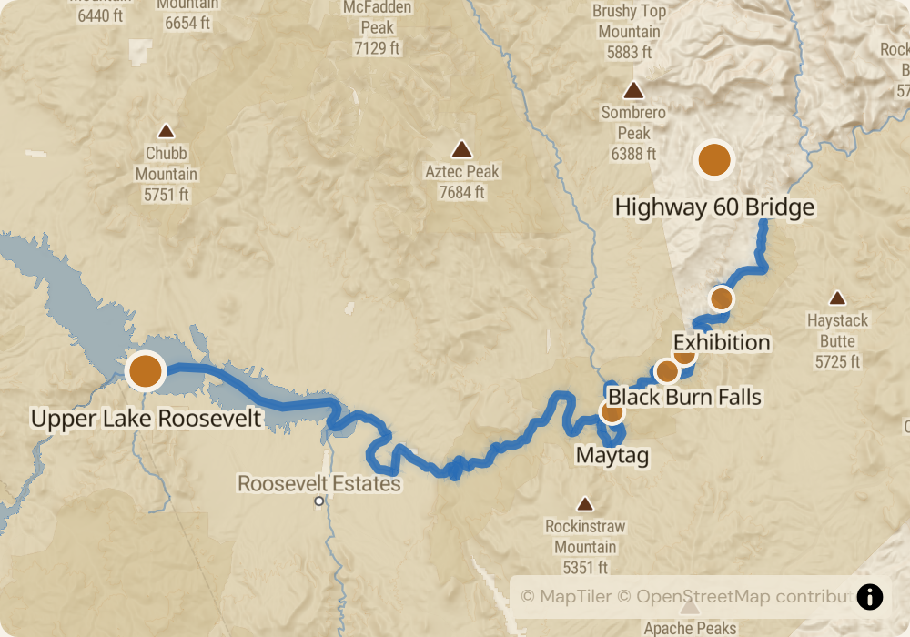
52 miles through a desert canyon that only runs during spring snowmelt from the Arizona White Mountains. Class III-IV with some of the steepest gradient in the system - the first 20 miles drop about 800 feet, forming named rapids at regular intervals: Exhibition (mile 5, Class III-IV), Black Burn Falls (mile 10, Class III+), Quartzite Falls (mile 12, Class IV - once a Class VI waterfall before it was dynamited in 1993 to a runnable drop), and Maytag (mile 17, Class III-IV). Below mile 20 the gradient eases and the canyon opens into desert bench country with cholla, ocotillo, and saguaro on the banks.
The permit
USFS-issued through recreation.gov. Lottery runs December for launches between March 1 and May 15. Odds are reasonable - roughly 20-30% for most dates. Fall-season permits aren't offered because the river doesn't run. The Salt is one of the only permitted desert rivers that runs on spring snowmelt alone - dam-free, and the season is entirely dependent on Arizona snowpack.
Timing
Season is entirely snowpack-dependent. In a 100%+ snow year, flows run 1,500-3,500 CFS from mid-March through early May. In a 70% year, the season might be 2-3 weeks in April with flows at 800-1,500 CFS. Below 600 CFS the run becomes bony and technical; above 4,000 CFS Quartzite and Maytag become serious. Check AZ White Mountain snowpack in January - if it's below 80% by April 1, expect a compressed window.
Logistics
Put-in is the Highway 60 bridge at the Salt River Canyon near Globe, AZ. Take-out is Upper Lake Roosevelt, reached from Globe via the Apache Trail. Shuttle is 120 miles through the Apache Trail and Globe area, $400-600 with a company. The Apache Trail is partially gravel and slow. Take-out coordinates vary with reservoir level.
Monitor Salt River Canyon for cancellations
We poll recreation.gov every minute and email you the moment a permit opens up. No app, no hype, just the alert.
Start monitoring